Weekly photo challenge: Street life

I’m not old enough to have taken these photos.  Lol.  They’re from my father’s war album of photos taken in 1941-42.  He was sent to the Middle East for several months and brought back photos of the places he passed through.  He wasn’t always the one behind the camera;  some of them came from friends in swaps, so I can’t know who captured these images.

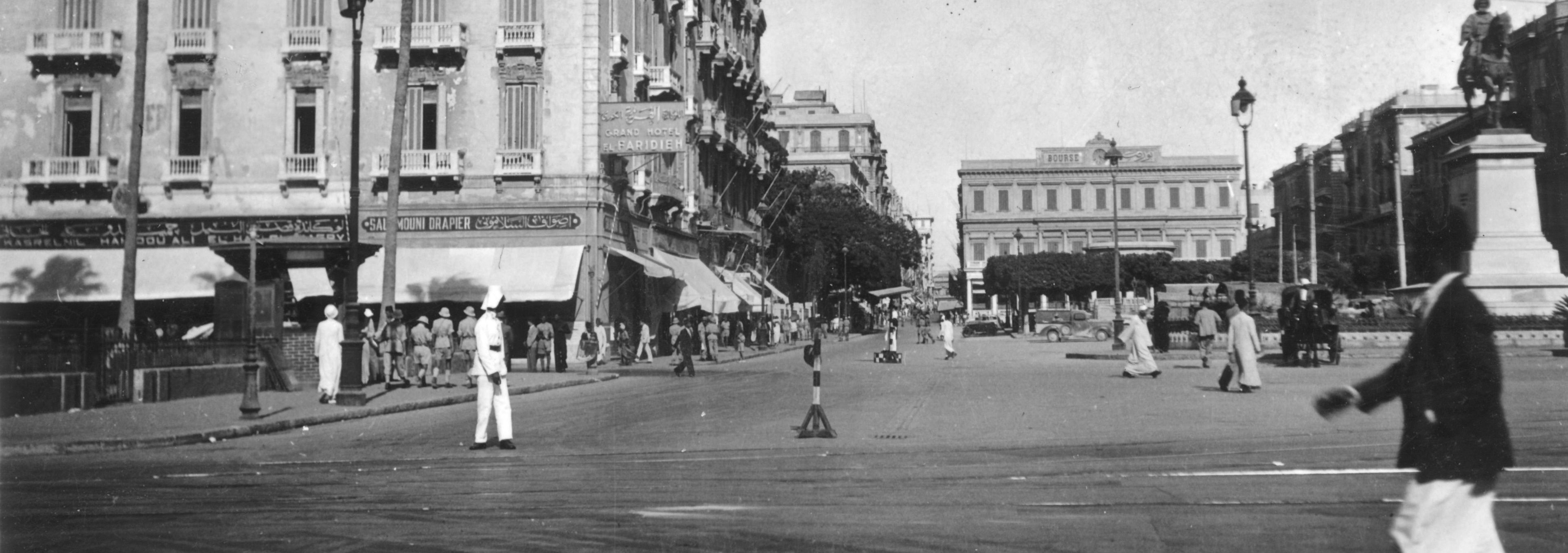
The first one is a snatch of street life during the early years of the war in Alexandria, Egypt.  Not much traffic!

In the mid-19th century, under the French, this was the Place des Consuls, where several Consulates were situated in what was then a cosmopolitan Alexandria.  It was then renamed Mohammed Ali Square in 1873 after the statue of the Ottoman governor, Mohammed Ali, was placed in the square (on the right of the photo).  British naval forces bombarded the area in 1882 and destroyed most of the original buildings.  It’s now Midan al-Tahrir, Tahrir Square (same as the famous square in Cairo).  In English, it’s Liberation Square.

Mohamed Ali Square, Alexandria, Egypt, c1941
Mohammed Ali Square, Alexandria, Egypt, c1941

The photo below is from the same album, but is unidentified.  It’s in the same era, and probably in Egypt, definitely in the Middle East, definitely during the war.  I like the perspective, the way the street curves into the distance behind buildings, and the way the buildings are flush with the street.  It’s not so much about street life since everyone seems to be inside except for a woman and two children quietly making their way  home.  The scalloped detail on the rooflines is particularly clear in monochrome, as is the mass of (what looks to be) a dovecote on the right.

Street scene, 1940s, Egypt?

I’m very thankful these days that my family kept these photos.  They’re possibly more meaningful now that several decades of history have passed, and we can compare the scenes then and now (thanks to all the images online).  Try looking for current photos of Tahrir Square in Alexandria.  The statue of Mohammed Ali is still there, but the square looks very different otherwise.  But perhaps black and white hides some of the grit of street life.

*****

One trip EVERY month: March

This month we went to the southern highlands of New South Wales, stopping at Bowral and Sutton Forest. It’s a region of retirees and tourists and businesses that accommodate one or the other.  (I’m neither; I was visiting an aunty, who is retired.)  Historically, Bowral was a rural retreat for the well-heeled of Sydney who built a number of manor houses on large estates, many of them now accommodation for expensive weekends away.  These days there are also a large number of homes owned by ex-Sydney residents who’ve worked hard all their lives and can afford a comfortable retirement in this cool, green, historical region.  Bowral is also famous for its association with cricketer Sir Donald Bradman, which is interesting if you like cricket.

Garden lighthouse Bowral

In Bowral there are big big houses where the rich have indulged their whims.  Let’s say you made your money sailing the seas.  Then you could build a lighthouse-type structure in your garden and pretend you’re still out there on the ocean watching for land.  But not everyone in Bowral’s history has had buckets of money.

There are still a few poor cottages scattered surprisingly here and there.

Old house Bowral

It’s a place where nature has been tamed to suit the formal tastes of European settlers, with pines in lines and hedges with edges.  The garden seat in my header, off to the side under shady trees, was much more inviting than these stiff square plantings.  Not to worry, untamed Australian bush is never far away – once you’re out of town and back on the highway, this is all you see either side of the road.

Roadside Federal Highway

The southern highlands attracts people with money and where there’s money there’s shops, particularly shops that sell non-essentials:  craft shops, antique shops, home decorating shops, country clothing shops and book shops (actually, book shops are essential).  In Sutton Forest there’s even a shop for everything, called The Everything Store, with an American flag flying beside two Australian flags.  There are markets selling fruit and vegies and cakes and nuts.  This one had all sorts of things hanging from the ceiling, even a colourful umbrella sheltering garlic bulbs.  I was amused by the nut warning, which we find on everything now, even on nuts!

On the way back we passed Lake George which is presently empty and used by farmers to graze sheep and cattle.  It’s an endorheic lake, meaning it doesn’t flow into rivers or the sea, and fills and dries out for short or long periods.  I’ve lived in this region for 17 years and rarely seen it full or even half full.  It all seems very mysterious, and urban myth makers make the most of the disappearance of the water and its destinations.  In the past decade the ridge on the lake’s south-eastern side has been embellished with 67 wind turbines, making the Capital Wind Farm the largest in New South Wales.  Here’s a photo I took as we drove past:  lots of clouds, ridges, wind turbines and sheep.  Zoom in to see.

Lake George

You know you’re close to Canberra when you see Black Mountain Tower come into view.  It’s a comforting sight, knowing the long trip is nearly at an end.  The layers of ridges of the Brindabella Ranges are so beautiful from this point on the road that it’s like driving into a landscape painting.

Approach to CanberraThanks for reading about our trip to the southern highlands.  And thanks to Marianne for her challenge to take one trip EVERY month.